| |
One hike seemed nearly vertical up and down. Another offered stunning views of glaciers and, surprise, snacks at a mountainside teahouse. Yet a third displayed sprinkling views of waterfalls. The challenge when staying in and near Banff National Park in the Canadian Rockies is not finding a great place to hike, it's deciding which ones to take. Here's a trio of offerings, some for people seeking a challenge, others to simply enjoy the art of being.
Ha Ling Peak
| |
 |
|
If we had realized what we were getting ourselves into, we might not have done it. Sometimes, ignorance really is bliss.
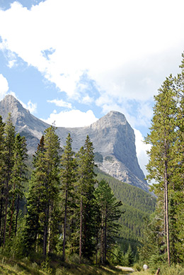
From Canmore, a British Columbia town south of Banff, Ha Ling Peak looks like a giant thumb, a toweringly tall, gargantuan thumb. Because my guidebook downplayed the drama—it's only 1.7 miles from the trailhead to the summit and rated “easy” to “moderate,” we nonchalantly packed up and headed out. That distance, we learned, felt much longer.
Make that Much Longer, partly because it gains a billy goat steep 2,407 vertical feet to a summit of 7,897 feet. This is true because partly because the trail is frequently slip-slide rocky and, near the top, dissolves into a windy, pick-your-own-way route. Thankfully, we carried hiking poles, which provided traction on the slippery uphill slopes and preserved our knees on the rocky-rolly descent. |
|
| |
Ha Ling looks like a giant thumb |
|
|
|
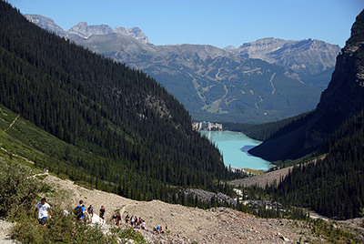
Hikers struggle up above tree line
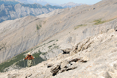
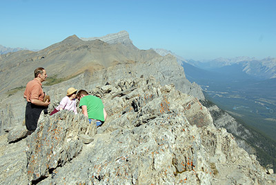
The hike begins at the Goat Hill parking area, immediately and steeply forging uphill. It never ever relents. The trail quickly climbs through forested terrain, then edges along semi-exposed ridges until reaching the final tug, a series of steep switchbacks on talus and scree. Climbing, scrambling it felt like walking on ball bearings and marbles.
The sense of steepness didn't genuinely come alive until we were above tree line, where the trail dissolved into a route. We could see where we were going, and it did not look promising. It helped that people on their way down voiced words of encouragement, telling us, “It's worth it.”
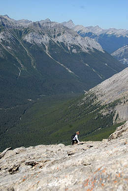
And it was. From the top, Canmore and the expansive Bow Valley dominate the 360 degree view. The sights include nearby Mount Rundle and several hundred peaks, including distant Mount Temple, the Goat and Fairholme ranges, Mount Lady MacDonald and Grotto Mountain.
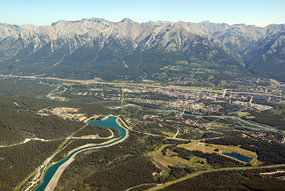 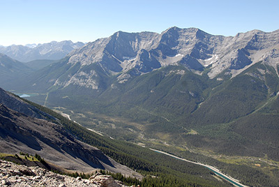 Canmore and the Bow Valley from atop Ha Ling Canmore and the Bow Valley from atop Ha Ling
The end of the trail is definitely the end of the trail. At spots, one more step would have resulted in a 2,000 foot free-fall to the valley below.
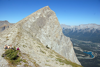  Ha Ling Peak is seriously steep Ha Ling Peak is seriously steep
The peak's name has evolved. Originally the mountain was locally known as The Beehive. In 1896, Ha Ling, a Chinese cook for the Canadian Pacific Railway, accepted a $50 bet from a person who said he couldn't climb the peak and plant a flag on its summit in less than 10 hours. A story in the October 24, 1896 Medicine Hat News reports that Ha Ling began his climb at 7 a.m., and was back in time for lunch. When his claims were challenged, he led a party of doubters to the summit and planted a much larger flag beside the original. In his honor, the mountain was renamed Chinaman's Peak. More than a century later, when the term "Chinaman" was deemed derogatory, it was renamed Ha Ling Peak.
Savoring the scenery
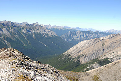
After savoring the scenery, we took the short detour to Miner's Peak. It's a much easier, firmer trail and provides another perspective, including a dramatic angle of Ha Ling. Summit Ha Ling first because from Miner's Peak, it looks improbably steep.
It's a challenge, but Ha Ling is actually the least difficult of several nearby alternatives. No matter the level of difficulty, it's a definite "thumbs up" trek.
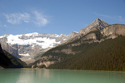
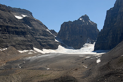
The Plain of the Six Glaciers
Everyone who visits Banff visits Lake Louise. That's one of the reasons travelers go to that part of the Alberta Province. A pretty high percentage of visitors walk at least a portion of the gentle, level 1.2-mile trail from the lodge that flows along Lake Louise's north shore.
 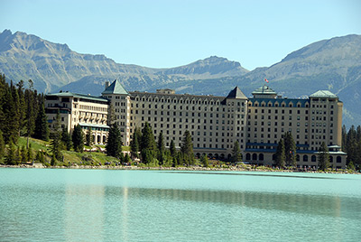 Lake Louise Fairmont Lake Louise Lake Louise Fairmont Lake Louise
Looking back down the trail
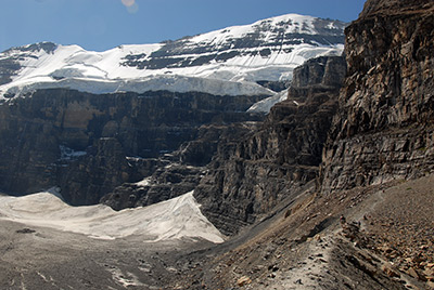
The crowds thin where the trail leaves the lake and becomes the Plain of Six Glaciers trail. Over another 2.2 miles the trail climbs through a sub-alpine forest, gaining 1,100 vertical feet on its way to the Plain of Six Glaciers Teahouse, built in 1927 for Swiss guides leading parties up Mount Victoria. Getting there is worth the effort because of dazzling views of the terminus of the Victoria Glacier, Mount Victoria, the Mitre, Mount Leroy and, looking back, Lake Louise and the suddenly tiny lodge. A spur leads to the two-story teahouse, which offers lunch and snacks, and sits in a meadow surrounded by stunted alpine fir and larch, a scene stolen from "Heidi" or "The Sound of Music."
| |
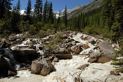
Roaring river |
|
The Mitre rises above the Victoria Glacier |
|
Dynamite scenery
But we heard no "sound of music" after trooping another mile. We followed a lateral moraine and rocky slope overlooking the icy, boulder-covered glacier and couloir that leads to Abbot Pass, a rubble- strewn route with tons of tongues of glittering ice. Further up the valley, where the trail doesn't go, the scene was dynamite, and so were the natural sounds. The otherwise blissful silence was several times shattered with ice falls, the sound crackling in a series of ear-numbing explosions. One Niagara Falls-wide calving filled the sky with showers of snow and ice.
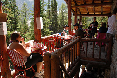
Teahouse reprise
We retreated to the teahouse and found an upstairs table, where we munched our lunches, thinking, ironically, of Eugene O'Neill's comedy, "Ah, Wilderness!"
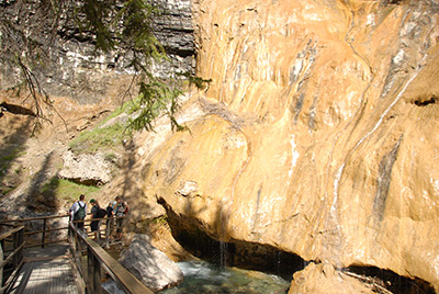
Johnston Canyon
Yes, the trail is crowded, but that's no reason not to make the short hike up Johnston Canyon. One guidebook describes it as "Busy But Beautiful," and that's an apt description. The walk, 1.7 miles one-way, begins at the Johnston Valley Resort along the Bow Valley Parkway. The wide paved path works its way gently up uphill, slicing through the scenic canyon with the aid of suspended catwalks that overlook rumbling Johnston Creek before reaching the 66-foot tall Lower Falls in about three-quarters of mile. A short tunnel provides passage to an up-close, usually wet view of the falls. Soak it in, literally and physically, but keep going.
 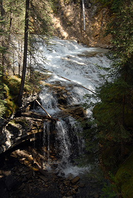
Catwalks along the trail Rumbling creek
The way forward steepens, crosses more staircases and passes alongside the Travertine Drape, a mineral and algae wall. Views of the usually surging creek are abundant through the narrow canyon. At a small waterfall we watched as people crossed the fence, stood at its edge, then launched into space, landing in the pool below the small falls.
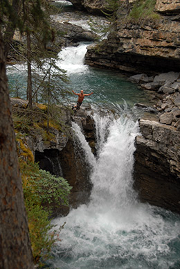 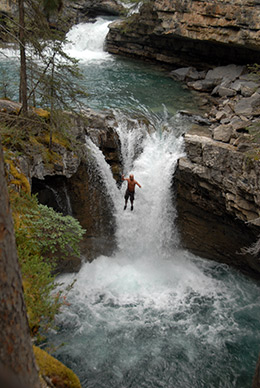  Ready, set, jump Upper Falls tumbles 130 feet Ready, set, jump Upper Falls tumbles 130 feet
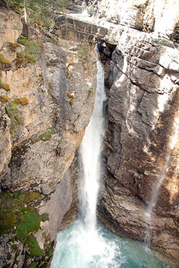
Further along a junction offers two choices - an uphill fork for an over-the-top view of the 130-foot tall Upper Falls, and a downhill branch that drops to a platform at the bottom of the falls. Take your choice on which you visit first, but do both.
When You Go
Because of the obvious Canadian Rockies tourism appeal, books about the region are plentiful. For the Ha Ling Peak trail, which is outside Banff and Jasper National Parks, the best information came from the lovingly irreverent "Where Locals Hike in the Canadian Rockies," by Kathy and Craig Copeland. They're also the authors of the wonderfully informative, also chippy, guide, "Don't Waste Your Time in the Canadian Rockies: The Opinionated Hiking Guide." The Copelands offer unabashed pros and cons on hundreds of hikes. Helpful, too, was the Lonely Planet's "Banff, Jasper and Glacier National Parks" and "50 Walks and Hikes in Banff National Park," by Brian Patton and Bart Robinson.
About the Author
Lee Juillerat is a reporter-photographer for a daily newspaper in Southern Oregon, author of two books about Crater Lake National Park, editor of travel and biography books, and freelance writer with hundreds of stories published in various magazines and newspapers, including the New York Times, Sunset, Northwest Travel, Oregon Coast, Range, Capital Press and the Shaw Historical Journal, among others. He can be contacted at 337lee337@charter.net
|
|