 |
|
PATAGONIA: PICTURE PERFECT PEAKS AND TRICKY TREKS |
|||
Story and photographs by Katrina Chen |
There was a fire in my lungs despite the snow on the ground and 80 mile-an-hour winds
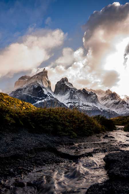
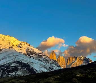
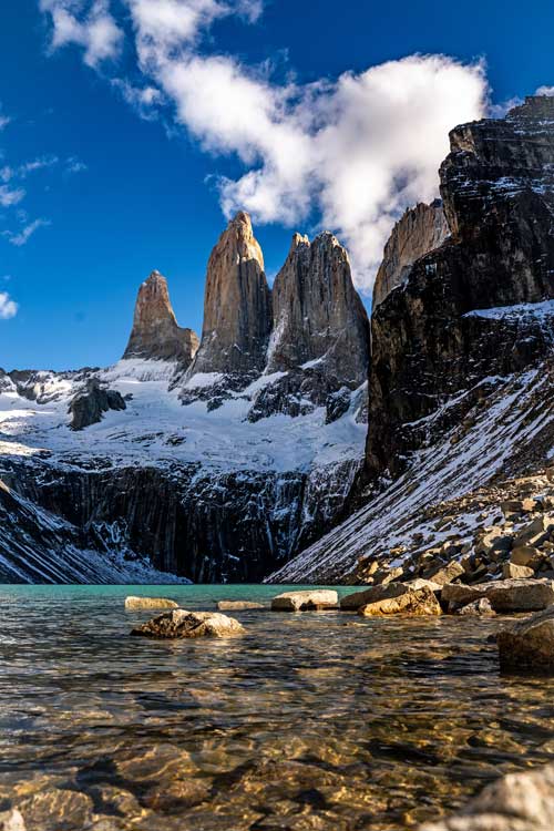
encouraging my demise. Three towers of ancient rock, snow, and ice stood proudly in front of
me. A glacial turquoise lake framed the base of the towers. But before I could admire the view I
had sacrificed my lungs and body to see, I needed a minute to recover. One thousand meters of
elevation gain through seven miles of hiking in four hours is no easy feat. And we were only halfway.
I bought a Patagonia rain jacket two years ago and knew I had to hike the mountains in Southern Chile. So, when I started planning my South America trip, this was the one location I was set on. But as always, I knew nothing about the region beforehand. Patagonia is a range of mountains in South America, divided between Chile and Argentina. Two of the most famous national parks in the region are Torres del Paine in Chile and Los Glaciares in Argentina. I I set up a volunteer opportunity with a hostel in Puerto Natales, a gateway city to Torres del Paine. Though the city is fairly large, it’s still an expensive two-hour bus ride from Torres del Paine. This makes it less worthwhile to visit the park just on a day trip; however, the most popular five-day W-Trek gets booked out months in advance. So when I got there, day trips were the consensus. As it turned out, I was eventually able to try three different ways to visit the park.
My first method of visiting was by bus. I went to do some small hikes to ease myself into
the gnarly mountains and freezing temperatures that I thought I had left behind in Canada. The
bus ride left brutally early - 6 am - and arrived in the park at 8 am. My goal was to do the treks
Mirador Cuernos and Mirador Condor; both can be done in a day by taking the bus to the
Pudeto bus stop. I layered up: beanie, buff, gloves, rain jacket, fleece, hiking pants, and of
course my thermals. I was prepared for the cold temperature, but I was not ready for the wind
that day. Upon stepping off the bus, I was blown back into it. I started up the hill that led to the
trail and realized that, though the hike was easy in terms of length and elevation, this wind was
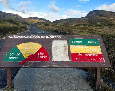
going to add a level of difficulty. At the entrance to the trail was a sign with the wind danger
levels: a safe green was 30-50km/h, a cautious yellow was 50-80km/h, and a dangerous red
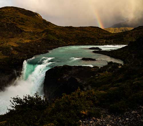
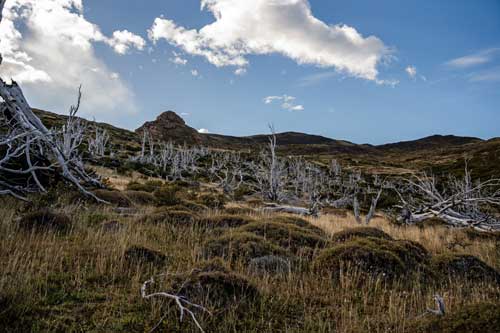
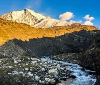
The trail itself was striking. Shortly along the trail was a monstrous waterfall with electric blue water. There was a slight mist in the air from the tumbling water and drizzle of rain, which created the most perfectly placed rainbow.
The trail had me walking between rolling hills, vast lakes, and stepping over puddles of icy sludge. I hadn’t thought I would need hiking poles, but I regretted not having them as soon as I took a step and ended up flat on my butt in a bush thanks to a gust of 80km winds.
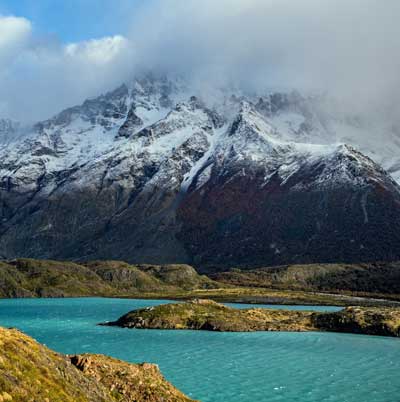
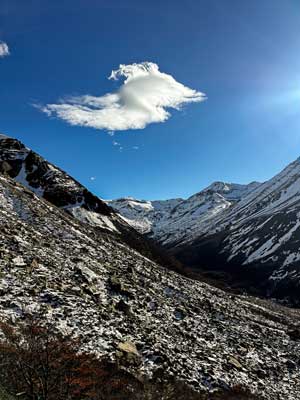
The strong winds meant the clouds cleared fast, and after an hour of walking, I had to stop to pick my jaw up off the ground. Before me stood the most insane mountain range I had ever seen. I’ve grown up in British Columbia near the Rocky Mountains; it’s hard for a mountain to impress me. These mountains did just that. The peaks were so sharp, the bases had so many colors from the autumn trees, and the snow added a majestic blanket. I spent so long admiring my first view of the Patagonian mountains from Mirador Cuernos that I ran out of time to do my second hike. But I could not care less as I boarded the bus back to Puerto Natales; I was overjoyed by the beauty I had seen that day.
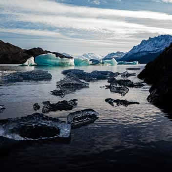
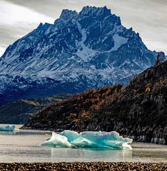
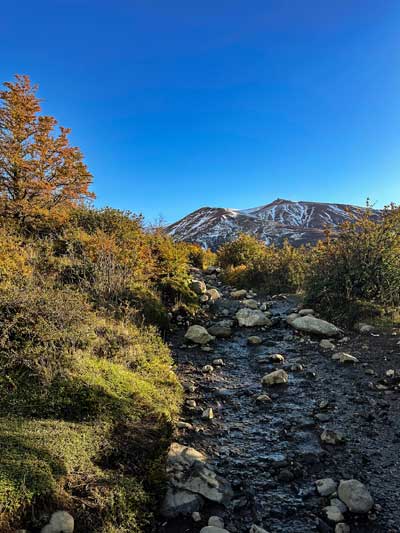
My next adventure to the park came by renting a car. I met twin brothers from Germany who were working at the same hostel. On our free day, we wanted to have free rein of the park, so we rented a car and set off. The drive there was gorgeous; we passed by many mountains and lakes. At this time of year - April - it was autumn in this region, so the trees were a symphony of reds, oranges, and yellows. There’s one main road that goes through the entirety of Torres del Paine, and renting a car ensured that we had the chance to see it all. Our first stop was Grey Glacier Lake. From a distance, the bottom of the glacier was visible. Pieces of ice melted off and floated down the lake, so we could retrieve and hold pieces of glacial ice as they washed up onto the shoreline.
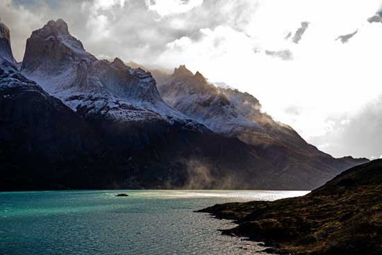
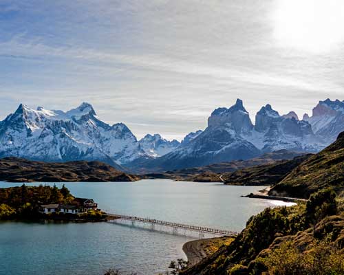
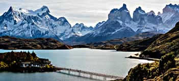
We then headed to the Mirador Condor viewpoint, the hike I had wanted to do during my first visit; the view from here was serene. A long bridge crossed the lake to a little island, and with the mountains in the background, the image was framed to perfection.
We then drove the winding roads to the Mirador Cuernos trail. We didn’t walk the full trail, but the weather was perfect - sunshine and no wind - making it much more enjoyable than my first windy experience. We kept going to Mirador Nordenskjöld, which offered an impressive view of Nordenskjöld Lake.
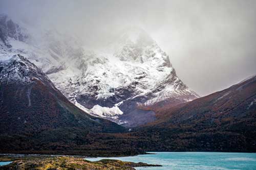
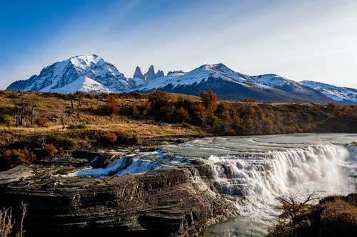
Our second-to-last stop was Cascada Rio Paine. This cascade was the most favorite among all the waterfalls I’ve ever seen. The commanding power of the crashing water combined with the distant mountains framing the three towers took our collective breath away.
Our final stop was Laguna Azul, a beautiful blue lake outside of the actual park. From this vantage point, we could see the same mountains beyond the lake, making it a beautiful spot to catch the sunset. Even though we almost got the car stuck in a giant puddle, we got there with lots of time to take photos and drink in the panorama. The sunset turned the mountains orange and left us longingly saying goodbye.
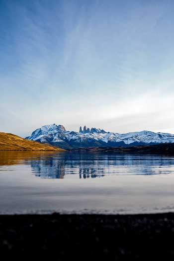
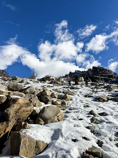
For better or for worse, my third and final way to the park was the most memorable Patagonian experience. The most common trek in Torres del Paine is the Base Towers. This hike is either the start or end of the five-day W-trek, and is the centerpiece and staple of the park. The destination of the hike is a glistening lake in the mountains, backdropped by three pillars of rock; the three pillars are where the name Torres del Paine comes from. I didn’t get to do the entire W-Trek, but I was determined to do this so I could walk away from Patagonia having done one of the big hikes. I had heard it would be difficult but doable in a day, and that sounded like an invitation to me. However, as the autumn transitions into winter and more snow and ice blanket the ground, the park will close trails or require the accompaniment of a certified guide. The day before I had planned to do this trek, it was announced that access to the Base Towers would require a guide. My hostel set me up with a guided group trek, which covered that base. The next day was an early wake-up - 6 am again - but the pure adrenaline coursing through my veins was a shot of wake-up juice. The day would require a 1,000-meter elevation gain, a 15-mile out-and-back, and would take roughly nine hours. My previous trek record had been only half those numbers, but what better time to break records than now? We started the trek as the sun rose over the entire park. This was one of the most surreal moments; a golden light bathed every surface within sight, but my smile was brighter than any light.
I had my hiking poles, all my layers, snacks, and cramp-ons ready. I would conquer these mountains. But thirty minutes later, I realized what I was in for. I was keeping a steady pace, at the front of my 12-person pack, barely sweating, until the incline. The Base Towers hike involves two prominent inclines, one 400-meter ascent at the start meant to be done in an hour, and a second 400-meter ascent in the last 0.75 miles; the middle section goes through some rolling hills known as the Windy Pass, a gradual incline through a valley, but prone to strong winds. About 30 minutes into the first incline, I began to wonder if I actually could complete this hike. I was gasping for air, my legs were dragging, and if I had measured my heart rate, it would have read “stop, please reconsider.” Luckily, I didn’t have a heart rate monitor on me. I kept going. Though I lagged behind the group, sticking with a guide whom I couldn’t talk to between my heaving and wheezing, I did survive the first ascent.
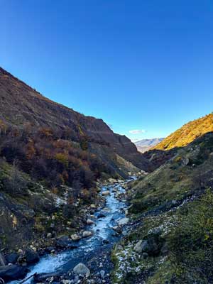
I persevered forward, the Windy Pass offering a gentle stroll rather than a gruelling hike. This is where I could take a moment to admire nature. The valley we were in had walls of warm autumnal trees, rocky drop-offs, a rushing river, and icy snow. Fortunately, the Windy Pass did not live up to its name; it offered a light breeze, so I had shed down to my thermal layer plus my coats of sweat.
We passed through rocks, forests, and rivers; two hours of a beautiful walk, then we reached the
It started okay, in through the nose, out through the mouth. There was a good number of hikers, meaning we progressed slowly while waiting for people to traverse the snowy boulders. But after 15 minutes, paces began to slow, and it became a battle between just me and the rocks ahead. I was losing. I would manage to climb three boulders before keeling over to catch my breath. Then another five minutes of jumping across streams and over tree roots.
My legs began to cramp and shake; if the freezing air hadn’t been immediately cooling my sweat, I would have been a puddle. But I told myself all that mattered was making it up. Whether it took 45 minutes or two hours, it was not a race. I just needed to get there. My vision was spotty, my head was pounding, my legs were buckling, my lungs had holes burned through them; one hour later, I fell to my knees in the snow facing a magical lake and three towers.
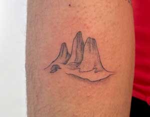
Though I still had to hike back, I knew it would go more easily. I was practically running back The first thing I did when I got back to town was book a tattoo appointment. I knew I needed this achievement commemorated. It not only made me believe in myself to do the physically impossible, but reminded me that I am the strongest person I know; all that matters is that I believe in myself. Only then can I overcome life’s most dismal downs and celebrate life's most daunting ups.
About the Author
|