 |
|
TREASURES OFTHE YUCATÁN PART 2: CHICHÉN ITZÁ TO ESCÁRCEGA |
|||
Story by Vicki Hoefling Andersen; photos by Andersen unless otherwise attributed |
|||
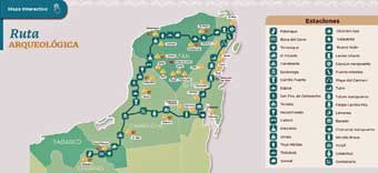
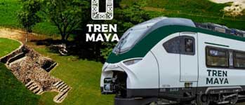
In Treasures of the Yucatán Part 1 (http://bit.ly/3BWHC7b) we explored the sections of the Tren Maya (Maya Train) from Palenque to Izamál. In Part 2 we continue the journey through a landscape filled with natural wonders, Colonial cities and designated Magic Pueblos, world-famous coastal destinations, and dozens upon dozens of ancient Maya sites. SECTION 4 of the Maya Train, first segment of the 277-mile long Tramo Caribe or “Caribbean Section,” runs between Izamál, Yucatan and Cancún, Quintana Roo, journeying a route filled with nature, culture, archaeological ruins, and a coastline that embraces a series of world-famous beaches and resort towns.
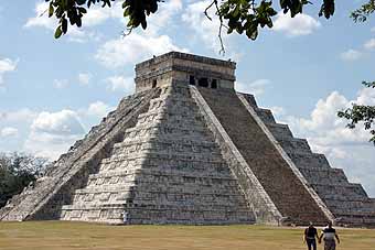
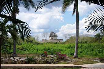
Chichén Itzá, designated a UNESCO World Heritage site and selected as one of the New Seven Wonders of the World, is arguably the world’s most famous ancient Maya city. The site is best known for the Pyramid of Kukulkán where the sun during the spring and fall equinoxes produces a shadow cast by the edge of the structure that resembles a serpent slithering up and down the main stairway. El Caracol, aka The Observatory and Chichén’s only round structure, was used for astrological observations and incorporated reflecting basins to help chart movements of the planets and stars. To this ceremonial center which dates to 1500 BCE, the Tren Maya project has added a train station, the Hotel Tren Maya Chichén Itzá, a new museum, and opened the Chichén Viejo area to visitors.
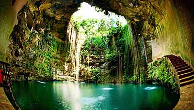
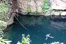
Two miles from Chichén Itzá is the 200-foot-diameter, 157-foot-deep Cenote Ik Kil where a carved stairway descends to a swimming platform. The cenote (a natural sinkhole filled with groundwater) gained fame hosting three years of Red Bull Cliff Diving World Series with professional cliff divers making the 100-foot jump from the top.
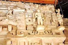
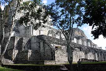
Valladolid is a Pueblos Mágicos honoring its Colonial architecture, picturesque cobblestone streets, charming churches, and crystal clear cenotes including Cenote Zaci located in the heart of the city. Eighteen miles north is the ancient Maya city of Ek Balam. Inhabited as early as 400 BCE, its most famous structure is the six-level Acropolis measuring over 500 feet long, over 200 feet wide, and over 100 feet tall. It Includes an intricate system of stairways, passages, rooms and temples as well as an astonishing façade of almost perfectly preserved high relief work and stucco life-sized sculptures. Sixty-six miles north of Valladolid, Río Lagartos Biosphere Reserve is famous for its iconic pink lakes, colonies of nesting flamingoes, and habitat to more than 400 bird species. SECTION 5 of the Tramo Caribe route is broken into two sections: Tramo Norte from Cancún to Playa del Carmen and Tramo Sur from Playa del Carmen to Tulúm. It provides access to some of the Riviera Maya’s most popular tourist destinations, from white sand beaches with crystal clear waters to ecological parks and ancient Mayan sites. Cancún’s Tren Maya terminal is conveniently located at the Airport. First settled by Mayan royalty around 250 CE, in1974, what was then a small fishing village of 120 people, Cancun was selected by a Department of Tourism task force for development in hopes of boosting the region’s economy. They built it and the people certainly have come. Nineteen miles north of Cancún, at the northern tip of the Mesoamerican Barrier Reef (the world’s second-longest and also known as the Great Mayan Reef), Isla Contoy National Park’s 12,602 acres is home to 152 registered bird species and four types of endangered sea turtles. Visitors can swim alongside whale sharks in the 146,000-acre Tiburón Ballena Biosphere Reserve. The Western Coast of Isla Mujeres, Punta Cancún and Punta Nizuc are National Parks where divers and snorkelers enjoy a feast of marine life.
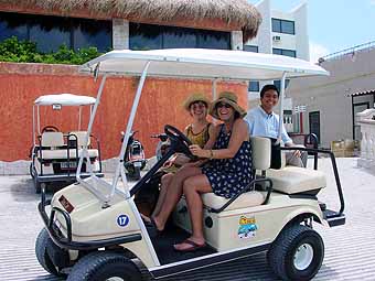
An easy 8-mile ferry ride across Bahía de Mujeres (Bay of Women) from Cancún, Isla Mujeres is designated a Pueblos Mágicos for its charm, stunning white-sand beaches and clear sapphire waters. On this, the Easternmost piece of land in Mexico, just five miles long and less than one mile wide, most folks commute via golf cart. The island was a pilgrimage site where Maya women came to venerate Ixchel, goddess of the moon, love and fertility. Fishermen harvested its abundant salt supply. Pirates, including Henry Morgan and Jean Lafitte, concealed their ships in Makax Lagoon. (For more information check out my story Isla Mujeres: The Island of Women https://bit.ly/3xLoSp3)
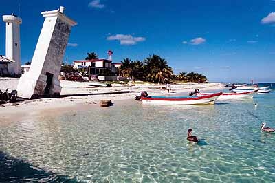
Another Station along the Tramo Caribe Norte route, Puerto Morelos is one of the oldest seaports in the Yucatán and a typical fishing village until it woke up to find ex-pats building houses on its pristine beach. The Tilted Lighthouse, a local landmark, was the result of Hurricane Beulah washing away its foundation in 1967. Puerto Morelos Reef National Park covers 22,239 acres of land and sea, home to almost 700 species of marine fauna and a variety of endemic flora.
Playa del Carmen began life as another small fishing village but has become one of the fastest-growing towns in Latin America. An extremely popular vacation destination for North Americans, pedestrians-only Fifth Avenue is lined with restaurants, shops and nightlife. Playa is the departure point for visitors to Cozumel just 15 miles offshore.
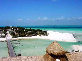
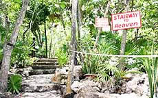
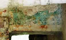
The Magical Pueblo of Cozumel is Mexico’s largest island stretching 30 miles long and 10 miles wide. Inhabited by the Maya since 300 CE, it flew below the radar until the early 1960s when Jacques Cousteau declared the rich marine life and crystal-clear waters of Palancar and Chankanaab reefs one of the world’s best snorkeling and scuba diving destinations. The island’s laid-back vibe is epitomized by Coconuts Bar & Grill where signs welcome patrons to its Stairway to Heaven, point out No Shirt-No Shoes-No Problem, and Cuba a quick 90-mile swim away. Inland from the island’s unspoiled beaches, El Cedral’s early Maya traces have been replaced with brightly painted homes. The UNESCO World Heritage Site of San Gervasio preserves the ancient Mayan pilgrimage site located in a forested setting in the northern part of Cozumel. Among its 40 structures is Las Manitas or “Little Hands,” part of the site’s most complex structure and whose inner shrine still shows red handprints and traces of paintings.
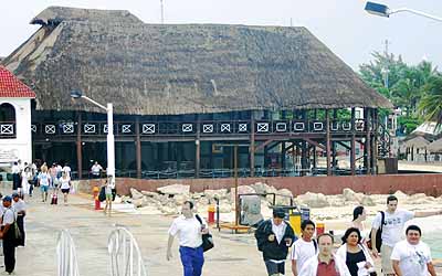
The second half of Section 5’s Tramo Caribe route, Tramo Sur, connects Playa del Carmen and Tulúm, with Xelhá Lagoon National Park just 30 miles south of Playa. SECTION 6 of the Tren Maya covers the 158-mile stretch from Tulúm to Bacalar and includes some of the best beaches on the Riviera Maya, a 100-mile sweep of Caribbean coastline stretching south from Cancún. Tulúm’s Tren Maya station is actually located inside a new 7,200-acre nature reserve, Parque del Jaguar. It extends from Tulúm to the Maya site and is nearly three times the size of New York City's Central Park, with walking trails, bike paths, beach access, a butterfly garden, and cenotes. The Hotel Tren Maya Tulúm is the largest of the new hotels and is conveniently located for train passengers. The town is properly called Tulúm Pueblo to set it apart from the nearby Maya site of the same name, and holds a Pueblos Mágicos designation for its nearby Maya ruins, cenotes, and powdery white-sand beaches.
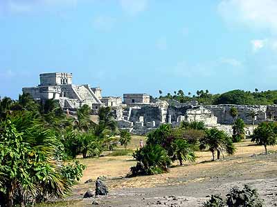
Tulúm Archaeological Site sits on a 40-foot high view-filled bluff overlooking the Caribbean Sea and a tiny cove with a picturesque white beach. Three massive walls enclose a 16-acre site with more than 60 consolidated buildings. The largest structure, El Castillo, may have been used for nighttime navigation since lights positioned in the two sea-facing windows shine a beam indicating the only navigable channel through the reef. The most extensive archaeological investigation in Tulúm’s history has been undertaken as part of the Tren Maya project.
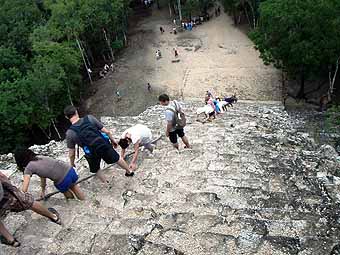
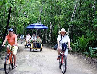
Thirty miles northwest of Tulúm, Cobá reached its peak around 750 CE with 50,000 inhabitants spread across 35 square miles. The city is estimated to have more than 6,500 structures with 20 unexcavated constructs for every one that has been restored. The Nohoch Mul Pyramid towers 138 feet making it the third tallest on the Yucatán Peninsula, with a steep stairway leading to views of three lakes and the surrounding jungle. Cobá was the hub of a network of more than 50 sacbéob or “white roads” running across 100 miles in almost perfectly straight lines to other Maya centers, some so large they can be seen from space. Between 10 to 15 feet wide, they were usually elevated one to three feet above the jungle floor and today make perfect roadways for roaming Cobá via bicycle or pedicab.
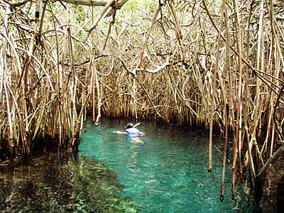
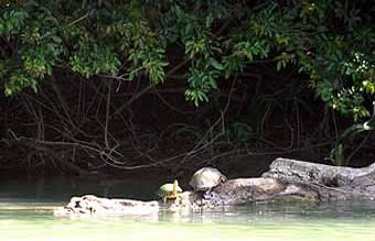
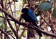
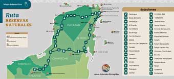
Less than 13 miles south of Tulúm, in the northern portion of the Sian Ka’an Biosphere Reserve, the ancient Maya settlement of Muyil served as an inland port for Cobá. Traders used a system of canals connecting Muyil to Laguna Muyil, then to Laguna Chunyaxché, and ultimately the Caribbean. Among the ceiba, zapote and ficus trees, six pyramids and more than 100 mounds and temples conceal numerous subterranean chambers. The Sian Ka’an Biosphere Reserve, just 25 miles south of Tulúm, is a UNESCO World Heritage site celebrated for its vast biodiversity. The 1.3 million-acre Reserve’s name means 'Origin of the Sky' and includes aquatic, coastal and terrestrial ecosystems linking a barrier reef, beach, mangroves, wetlands, fresh and brackish water lagoons, and tropical forests. This reserve is home to over 350 avian species including woodpeckers, toucans and parrots - also crocodiles, pumas, jaguars, ocelots, and three species of turtles and monkeys. SECTION 7, the Selva Tramo or “Rain Forest Section,” covers 178 miles between Bacalar in Quintana Roo and Escárcega, Campeche. Along the way are dazzling lakes, amazing archaeological sites tucked into tropical rainforests, and reserves rich with wildlife.
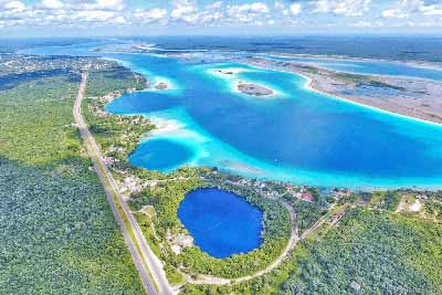
Pueblo Mágico, located in Bacalar, is recognized for its cultural, historical and architectural importance. It sits on the shores of Mexico’s second-largest lagoon, the 37-mile-long Lagoon of Seven Colors, which has been called the “Maldives of Mexico.”
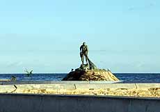
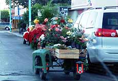
Located along the coastline of Chetumal Bay just north of the Belizean border, Chetumal is the capital of Quintana Roo and is easily accessed by a train station located at the Chetumal airport, or by road. The Pescador al Momento or Fisherman Monument located on the Bay is a fitting symbol of Chetumal’s inhabitants and one of the most representative icons of the city. Today’s workers and vendors add color and curiosity as they negotiate their way through city traffic. The Museum of Mayan Culture is a modern three-story exploration of Mayan cosmology. The Yook’ Ol Kaab
Planetarium and observatory includes a 16-inch telescope for scanning the heavens. Chetumal Bay is home to a Manatee sanctuary with one of the largest populations of this peaceful mammal in the wild. Divers enjoy exploring Banco Chinchorro Biosphere Reserve, a three-island atoll with at least nine shipwrecks just 50 miles east of Chetumal.
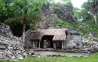
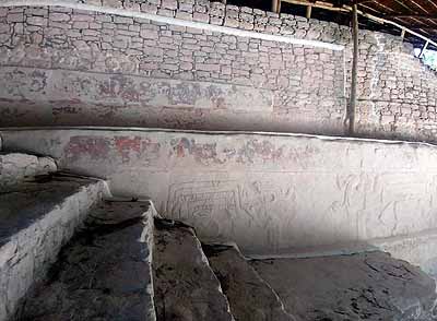
A short drive south of the Nicolas Bravo-Kohunlich train station, in the community of Nicolas Bravo, is the ancient Maya city of Kohunlich, which flourished from 300 BCE to 1200 CE. Surrounded by lush tropical jungle, much of the 21-acre site is still unexplored, but one of the most celebrated structures is the Temple of the Masks. Each side of the structure’s stairway is adorned with six beautifully executed and well-preserved nearly ten-foot-tall stucco masks of the Maya sun god, Kinich Ahau. (see my Transforming the Yucatán: Arrival of the Tren Maya - https://bit.ly/3L38B1M – for pictures and information about recent restoration work on the Temple of the Masks)
North of Nicolas Bravo is Dzibanché, founded in 250 BCE and whose tallest building, the Temple of the Cormorants, features steps with painted and carved murals.
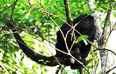
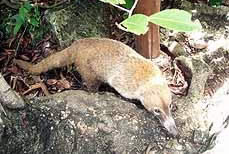
The train station at Xpujil is surrounded by ancient Mayan cities. This is the entrance to the Calakmul Biosphere Reserve with 1.8 million acres teeming with life. Over 1,500 plant species thrive in the rainforest, while hundreds of exotic bird species and troops of spider and howler monkeys make the canopy come alive. At ground level, jaguars, ocelots and pumas share space with less frightening hunters like the coatimundi.
Discovered in the 1930s on the western edge of town, Xpujil Archaeological Site includes the Building of the Three Towers, adorned with a trio of 30 to 40-foot-tall towers, a divergence from the usual twin constructs more typical for this region. Just down the road, Becán was an intellectual, astronomical and ceremonial center built between 100 and 250 CE and has some of the largest ancient structures in the State of Campeche, including Structure I.
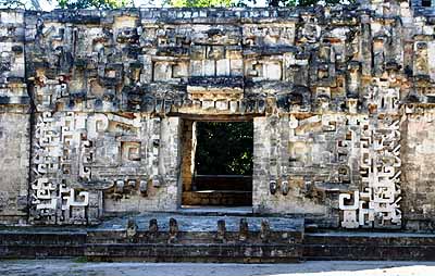
Six miles west of Xpujil, Chicanná – which in Mayan means “Serpent-Mouth House” – was named for the doorway leading into Structure II. This gigantic monster-mouth entry is complete with upper and lower fangs and represents the supreme Maya deity, Itzamná.
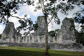
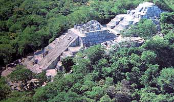
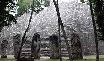
The Calakmul Tren Maya station and Hotel Tren Maya Calakmul are located in the heart of the Calakmul Biosphere Reserve near the archaeological site of the same name. One of the most powerful of all Maya dynasties ruled from Calakmul, a UNESCO World Heritage site which developed from circa 500 BCE to 1000 CE. One of the largest and best preserved sites in Mexico, it was the hub of road systems, water management features and agricultural terraces. It is known for colossal architecture such as Structure II, the largest part of which cannot be seen from ground level, and more than 120 carved stelae, the most numerous of any known Mayan site.
In Escárcega the final station along this stretch of track, visitors can enjoy local food, visit the City Museum, or peruse the variety of available merchandise without having to enter a store.
About the author:
|