Story & Photos by Vicki Andersen
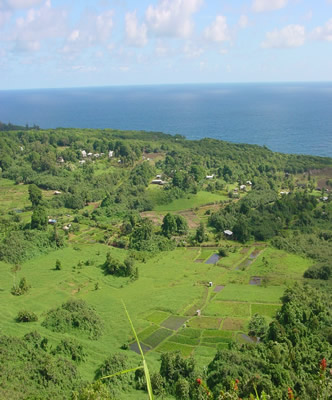
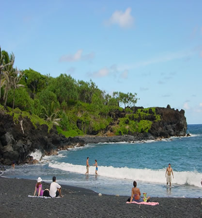
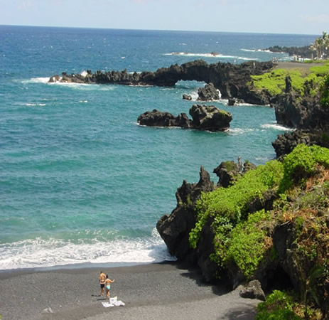
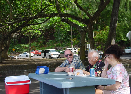
It would be hours before the sun arose, and I was busy checking my list: pastries hot from the oven yesterday afternoon in Lahaina - check; fresh fruit from the Honok?wai Farmers Market - check; chilled fruit juices - check; fat thermoses of hot chocolate and fresh-brewed Kona coffee - check. We had a long day ahead of us, and Id researched what I thought would be the perfect spot to enjoy a picnic breakfast, overlooking Honoman? Gulch and Mauis rugged eastern coastline.
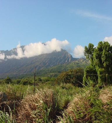
Not only were we taking the Road to Hana, but we were driving the full loop -- past Hana, across the southern tip of the island, and around the west side of Haleakala. Arguably the most famous scenic drive in Hawaii, it also had a rep for being a white-knuckle adventure, especially past Hana where all the guidebooks advised venturing only by 4-wheel drive. In preparation, wed swapped our rental sedan for an SUV and were ready to hit the road.
For nearly three decades my folks had made an annual ritual of spending a few weeks in Hawaii. For the last twenty, Dad had wanted to make this drive. Hubby and I had covered just about every mile of pavement on Maui except this road. As the years crept up on us all, and other drivers seemed to become less attentive and courteous, we decided to overlap a trip with my folks and make this a family outing. I wanted it to be special, over and above the awesome drive awaiting us... thus our breakfast date accompanied by a feast of island delectables.
In about an hour wed crossed the Island and were approaching P?ia, the last outpost for gas. It was still quiet in this charming little former plantation town. Perhaps some of the monks at the Mantokuji Buddhist Mission were stirring, but it would be a while yet before they rang their gong to announce the sunrise.
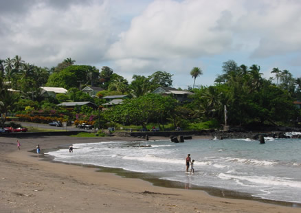
We were now skirting along the ocean and even though it was quite early and the winds were calm, I hoped to see a hardcore sailboarder challenging the waves at Hookipa Beach. This spot, world-famous for its wave and wind action, is considered the windsurfing beach on Maui and draws riders from around the world to its international championships. We had managed to be ahead of the traffic, but that also seemed to include the locals going about their business and play.
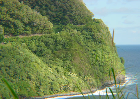
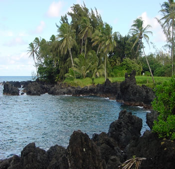
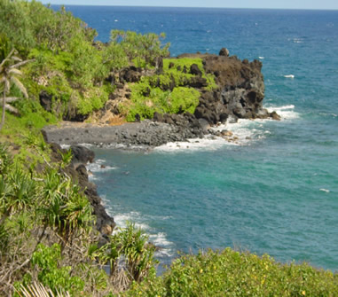
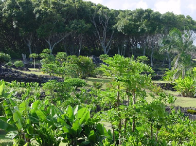
At mile marker 16, Highway 36 that wed been traveling from Kahului intersects with the Kaupakulua Road, a.k.a. Highway 365, and the mile markers return to zero. This is considered the official start of the Hana Highway which follows the windward shore, climbing in and out of valleys and presenting one piece of eye candy after another.
![]() |
|
|
HONOMANU BAY & ROAD
|
Built in 1927 by pick and shovel carving a path out of precipitous cliffs, part
of the road follows the 500-year-old Kings Trail. During the Makahiki
season, when ancient Hawaiians ceased their fighting and foes temporarily became
friends in feasting and celebration, the alii (Hawaiian royalty) would
walk this route. In 2000, the highway was designated Hawaiis Millennium
Legacy Trail in honor of its historic past.
Now an estimated 300-500 people drive this road every day, negotiating 617 hairpin turns and crossing 59 diminutive bridges, 46 of them one lane, and each carrying its own Hawaiian name. The speed limit dips to 10-15 mph in places, which is appropriate for the twisting roadway and stunning views unfolding around each corner.
This eastern side of the island is lush forest, and the area averages 340 inches of rainfall a year. Before the dirt and gravel road was paved, washouts were a common occurrence. But in true Hawaiian style, the locals took it in stride. Theyd simply exit their car, clamber over the mudflow, swap vehicles with someone on the other side, and continue on their way. More native Hawaiians live in this area than anywhere else on Maui.
![]() |
![]() |
|
WAIKAMOI BRIDGE
|
WAIKAMOI STREAM
|
Magnificent stands of bamboo now lined the road, interspersed with giant ferns
carpeting the slopes. The fragrance of wild ginger crept into the car, soon
joined by sweet guava and the rich, mossy rainforest smell. The Waikamoi Preserve
is considered a Cloud Forest, one of Mauis last large expanses of pristine
countryside. Streams carve their way through thick bamboo forest, and a nature
trail makes it easy for visitors to immerse themselves in the beauty. Our breakfast
stop at the Kaumahina State Wayside was a tranquil repast, surrounded by exotic
plants and views of Keanae Peninsula in the distance.
![]() |
![]() |
|
KEANAE FISH ON
|
KEANAE FISHING INLET
|
Many centuries ago an immense lava flow gushed down the Koolau Gap and formed
the Keanae Peninsula. Now verdant rainforest, swaying palms and banana
trees, and patches of taro cover the lava all the way to the edge of the rugged
coastline. An In the ancient village of Keanae, established on a fertile
sliver of land, a lava-rock church has nestled among the palms for over a century
and a half.
![]() |
![]() |
|
KEANAE CHURCH
|
PAUWALU POINT
|
Acres of eucalyptus and banana trees frame a pair of small waterfalls at Puaakaa
State Wayside. The freshwater pools into which they empty invited a quick and
very refreshing plunge. By now other visitors had joined the caravan making
its way to Hana, and a few of them stopped to feed the mongoose which poked
around in the vicinity.
![]() |
![]() |
|
PUAA KAA-1a
|
KAPUKAULA POINT
|
The road now ran alongside the Spreckles Ditch, a canal built over a century
ago by the East Maui Irrigation Company to provide water for the sugarcane industry,
and it continues to provide part of the local water supply. In this area, the
highway climbs to about 1,200 feet and cuts a path through the Hanawi rainforest.
Here and there, small dirt roads lead towards what must be small homes and farms, and a number of them offered self-serve stands based upon the honor system. At one, Dad replenished his mug with fresh brewed coffee. At another we plucked tiny bananas from a bunch which dangled invitingly, sun-warmed and sweet.
![]() |
![]() |
|
BLACK SAND BEACH
|
BLACK SAND BEACH
|
Waianapanapa State Park, a.k.a. Black Sand Beach, is composed of tiny,
smooth volcanic stones which glimmer in the sun. A lava tunnel at the end of
the beach opens onto the ocean. I could have spent the afternoon exploring the
half-submerged lava tubes, sea caves and arches, but we still had many miles
and adventures ahead of us.
![]() |
![]() |
|
HANA BAY
|
HANA LUNCH
|
For many, Hana is the turnaround point of their journey. Often considered the last unspoiled Hawaiian frontier, most of the population is at least half-Hawaiian. Nestled into a forest of tropical flowers, breadfruit and banyan trees, pandanus and taro patches, Hana was a retreat for ancient Hawaiian royalty. We headed to Tutus on Hana Bay, and found their hamburgers were extra tasty when eaten under a shady tree next to the Bay. Of course we finished them off with a serving of haupia (coconut) ice cream!
H?moa is home to a picture-perfect tropical beach, its crescent-shaped shore tucked below 4,000-foot high cliffs and surrounded by native vegetation. Author James Mitchner referred to it as the worlds most perfect beach. Further on, water draining off Haleakala plunges hundreds of feet into the kukui groves of Wailua Cove, forming Wailua Falls. The film Mutiny on the Bounty" was filmed in this stunning location, but today only a few locals were scampering about.
![]() |
![]() |
|
HAMOA
|
WAILUA FALLS
|
Beyond Hana the road is called the Piilini Highway, a.k.a. Highway 31,
but it is generally considered part of the Hana Highway at least as far as Oheo
Gulch. Mileage markers descend in sequence from this point, and the road narrows
and becomes even twistier. We had journeyed half a day and covered about one-third
our route, but there was one more MUST-stop point of interest: the Pools of
Oheo.
![]() |
![]() |
|
OHEO
|
OHEO
|
Often, and erroneously, referred to as the Seven Sacred Pools (there are more
than two dozen pools, and they were never considered sacred), countless tiered
waterfalls have hewn idyllic swimming pockets out of solid rock in Oheo
Gulch on their way from Haleakala to the ocean. A number of hiking paths lead
into bamboo forest, past ancient taro farms, and reveal other waterfalls hidden
in the lush foliage.
Tucked into another waterfall-filled valley, K?pahulu is rich in ancient history. There is archaeological evidence of prehistoric fishing villages and sites of worship. This area supported a population estimated at several hundred thousand when Captain Cook arrived. This is also where Charles and Anne Lindbergh choose to live after the death of their son, and Lindberghs final resting place can be found at Palapala Hoomau Church
Just past Alelele Stream, the paved road turned into a half-dozen miles of rugged dirt road, hugging the mountainside while precipitous cliffs dropped into the sea. The luxuriant vegetation of the Hana District gave way to Mauis Upcountry region, and views of Haleakala started to dominate the horizon. Swirling clouds often surge up Kaup? Gap, created eons ago when Haleakala blew out a large section of its rim.
We passed Kahikinui, where the first Polynesians made landfall after their voyage
from Tahiti. This area approaching Ulupalakua, considered the southern
start of Mauis Upcountry, must have presented a bleak sight to those first
settlers. As we skirted Ulupalakua Ranch, established in 1849, we saw
hillsides of cattle who call this 30,000-acre ranch home. It was in this vicinity
that we saw traces of Mauis last eruption in 1790, whose lava flows plummeted
into La Perouse Bay.
Soon we reached Kula, not far below the summit of Haleakala, and dramatic views
of Maui, Kahoolawe and Lanai unfolded before us. We had traveled more
than 130 miles, seen what seemed to be every variety of tropical foliage that
existed on these islands, and nearly encircled a volcano. There had been plunging
waterfalls, sparkling pools, towering cliffs, and craggy lava rocks frosted
with ocean foam. It had been a very, very long day - one which surpassed all
our expectations. Even folks agreed it was worth the 30-year wait.